Features
Made for the miles ahead.
Every feature exists because someone needed it and couldn't find it. Trail Sherpa is the thing that collects what worked and shares it forward.
How it works
Three motions, one loop.
01
Plan
Open the trail you care about. Drag your daily distances. The planner snaps to real waypoints and shows your elevation profile day by day.
02
Read
Browse the community sub for that trail. See what conditions other hikers reported this week, what campsites are full, what springs are running.
03
Share
When you get back: a trip report, a photo with the GPS pin attached, a condition update. Add to the pool other planners will draw from.
What's in the box
Ten features that pull weight.
-
Real planner, not just a map
Drag day-by-day segments along the trail, see live elevation, and snap to known campsites + water sources. Built on the same MapLibre + PMTiles stack the offline trail packs use.
-
Time-bound condition reports
Blowdowns, washed-out crossings, dry springs, closures. Reports auto-expire so the map shows what's true now, not what was true two seasons ago. Photos and GPS coordinates included.
-
Community by trail, not by feed
Each trail has its own sub. Trip reports, questions, and conversations stay scoped. One-level nested replies keep threads readable; like + save reactions, no downvotes.
-
Photos drop pins automatically
When you share a geotagged photo in a community post, it shows up on the trail map at the exact spot it was taken. Privacy-first: each photo has its own location toggle, off by default.
-
Search that understands hikers
Full-text search across every post + comment, with phrase quoting, OR, and negation. "Is there cell service" finds posts mentioning Verizon, signal, coverage, even when the exact phrase isn't there.
-
Static, sharable trail pages
Every trail has a public, no-login page with a suggested itinerary, day-by-day static maps, and conversion paths into the planner. Linkable, indexable, sharable on any platform.
-
Offline trail packs
PMTiles stored on Cloudflare R2 means the entire trail map (basemap, waypoints, contours) fits in a single file you can take into a no-signal valley. Coming with the iOS + Android apps.
-
Share itineraries to the community
One click turns your planned trip into a community post that others can fork, comment on, or borrow ideas from. The whole point of building the planner alongside the forum.
-
Trails split into stewarded sections
Every trail is divided into named segments with a dedicated maintainer. See who looks after each stretch, when they were last out, and what they logged. Condition reports anchor to the segment that owns them, so a blowdown at mile 14 routes to the right steward instead of a group chat.
-
Real stewards, named and credited
The volunteers who clear blowdowns and refresh blazes have a seat on the trail page, not just a logo in the footer. Each steward surfaces their trail name, last visit, and the hours they put in. Recognition the Google Doc never gave them.
For trail clubs
Retire the Google Doc. Keep the knowledge.
Every chapter has a shared spreadsheet, a group chat, and three decades of email. Trail Sherpa replaces all three with something that holds together when the volunteer roster rotates.
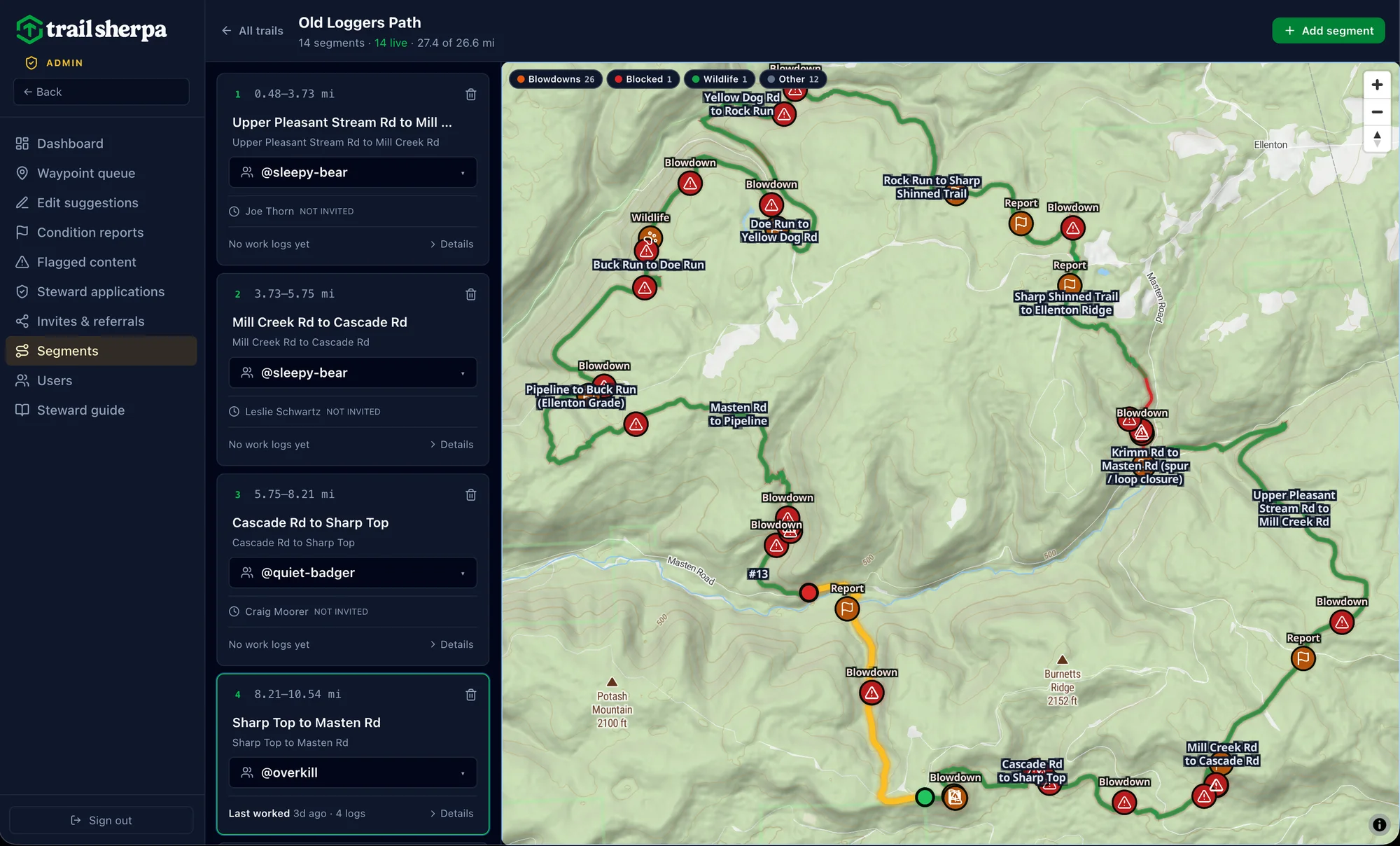
-
One source of truth for every section
Who maintains what, when they were last out, what they logged. All in one place that updates automatically. New volunteers inherit context instead of asking the retired trail boss.
-
Grant-ready hours tracking
Every work log captures date, hours, travel time, helpers, actions taken, and photos. Export a CSV for your grant report in one click instead of three nights with a calculator.
-
Hikers reporting into your workflow
Condition reports route straight to the responsible steward's email, with photo, GPS, and a direct link to the segment page. No scraping Facebook for "trail status this week?" posts.
-
No infrastructure, no procurement cycle
Free during the pilot. No seat licenses, no enterprise contract. Email us and we onboard your chapter in an afternoon.
First partner: Alpine Club of Williamsport, maintaining the Loyalsock Trail and Old Loggers Path. 36 segments, 23 named stewards, every work log since Spring 2026.
Try the planner with the Old Loggers Path.
Free trail pack, suggested itinerary, real condition reports. Sponsored by the PA Wilds Center.